 |
| Laguna Luspa |
I asked Josh what he wanted to do in Ecuador before he came down, and he told me he wanted to see the Andes and to do something I haven't done before. The first thing that came to mind was hiking in Cajas National Park. Cajas is a park just outside of Cuenca that is filled with glacial lakes and mountains. I had been wanting to go here for a while, and this seemed like the right time.
 |
| Starting out. |
 |
| We'd cross the mountains by the end of the day |

We got up early Friday morning and instead of taking the cheaper option of hopping on a bus to Guayaquil, we took a taxi instead. Our trail started at the far west end of the park, and in an area where non-guided tourists usually don't go. Taking a bus to an unfamiliar place and trying to get the bus driver to slow down and search for a random trial sounded like a disaster, so the taxi was the better option. It cost us $25, but took us exactly where we needed to be, and in about 45 minutes. Our path started just past the Huagraruma check-in office on the La Gran Osohuaycu trail. Our driver drove right through the checkpoint, and we didn't register or pay the $4 per night, per person camping fee. We probably should have. Amber had our itinerary though, so if we didn't come back, she could tell people where to look. He dropped us off at some restaurant and we walked down to the road and found a small bridge that started our journey. The goal for today was to get up and over the continental divide and then find a small cave marked on the map. The weather was perfectly clear, which happens only a few times a year in the Ecuadorian Andes. The scenery was incredible. We hiked past the largest lake in the park, Luspa, and followed it up to its source, passing several more lakes. After a bit of a push uphill with heavy packs, we made it to the continental divide. We were now crossing over to the Amazon drainage side of South America. We descended down toward our first camping site, following vague orange blazes that marked our trail. All we knew was that we were looking for a cave in the general area. From a distance, we saw a large rock with black marks from fires and we figured that was it. We got to it, and it wasn't much of a cave, but just a slightly covered overhang that might keep us dry if it rains. Good enough. The map showed another cave down the trail, so we tried to find it. I saw something that was a very small rock covering farther up a hill. The first cave seemed fine. We put our stuff down and in the last bit of daylight went to a nearby forest to see if we could get fire wood. The trees are called Polylepis and are strange looking trees that grow at high altitudes. They burn terribly though, and we had a cold, smoky fire that wouldn't stay lit. We were treated with an amazingly clear sky and new constellations that are only visible in the southern hemisphere. Our cave was at 12,500 ft, so my heart was beating faster than normal, but I got a few hours of sleep.
 |
| Creek crossing |
The next morning was cloudy and more the normal weather for Cajas. We took our time getting up but after some breakfast and coffee, we packed our stuff and continued on the Osohauycu trail. Our goal today was to meet up with the Inca Trail and get to another cave marked on the map, next to the Taitachugo lake. Our journey continued alongside another large lake, Osohuayco, and up a mountain pass, and on to meet one of the longest rivers in the park. We actually saw four other hikers today. They were coming down the hill with a guide and all of their packs strapped to a horse. Poor horse was overloaded and slipping in the mud more than we were. After we got to the mountain pass, we kind of lost track of the trail. Fortunately, we had a general idea of where we needed to go, so we just continued on and found it again. It started raining off and on the rest of the day. We reached the Inca Trail and it was much easier to follow. It was a lot muddier though. Josh only had tennis shoes and had a difficult time navigating the swampy, muddy areas without getting his feet soaked. It was slow going, but just before it got dark, we found the second cave. It was even less of an overhang than the night before, but it was dry and kept the rain and wind out.

 |
| We had to go up and over the hill in the background |

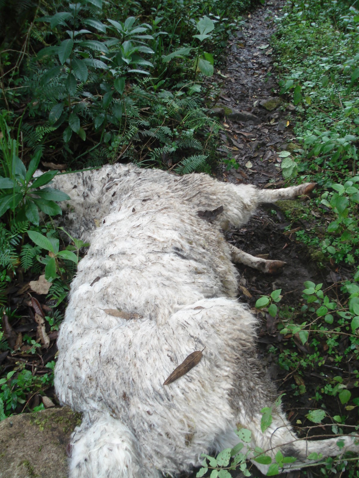
Today, we had a flight to catch at 2:20. We were still about 6 miles from the main road, and we didn't know just how long it would take to get there or back to Cuenca. We got up and left as soon as it was light enough to see. In the first minutes of our hike we were slowed down by a thick, Polylepis forest. We had to duck and crawl over trees and avoid huge areas of deep mud, all with packs on. At this pace, we'd never make it. Once we got out of the forest, the trail climbed up another pass, but then descended rapidly. The mud never let up, and sections of the trail were so steep, we pretty much were rock climbing down the rail. I was getting stressed that we weren't going to get back in time. We finally got to the bottom of the steep section and it was a little easier going. The trail opened up to a beautiful green field, and we were greeted buy a lone, white llama. It was odd that the llama just sat there and didn't move when we got closer, but then we saw why. Its mate was dead on the trail and he/she was mourning Not sure how it died, but it was blocking the trail and we had no choice but to step over a stiff llama. The end of the trail was in sight and we still had plenty of time. We reached the Llaviucu check point and the guard asked to see our entrance tickets. He was a little annoyed that we didn't register before we entered, but we just paid him the camping fee and left. We got to the main road at around 11:00 am and started flagging down any car that looked big enough to take us and our packs back to Cuenca. After a few tries, a guy in a SUV stopped and took us all the way back to our hotel. Everything worked out and we made our flight. I think in total we hiked about 15 miles. Cajas was an amazing place, and I could have easily spent a week or more out there. Here's some links I used to plan the hike. It's maps and trail descriptions.
http://www.parque-nacional-cajas.org/
http://www.etapa.net.ec/PNC/bib_PNC_doc/BibliotecaDescargas/MapaCajas/mapa-tiro-web.jpg
Interesting Fact: I think every culture has its own mythical hangover cure. In the United States, it was to eat fatty foods like bacon and fried stuff. Surprising. The word for hangover in Ecuador is chuchaqui (choo-cha-key) and their cure for it is seafood. Typically it comes in the form of cerviche, which is cold shrimp, fish, mussels, or a mixture, marinated in lime juice, onions, and tomato. I heard people say that a cerviche without a beer is not a true cerviche, so I think it's the fact that you have to drink beer with your cerviche that eases the hangover.
 |
| Josh on the continental divide |

 |
| The small rock in the middle is where we would sleep |
 |
| First night in the cave |

 |
| Lots of strange plants |
 |
| Second night's cave, Josh slept where he's standing |
 |
| I slept here |
 |
| We had to get down to the valley behind me |
 |
| Trudging through the mud and forest. |
 |
| The llama |
 |
| The dead llama |
 |
| Final part |
 |
| Weird abandoned buildings |
 |
| Heading out |


 Today, we had a flight to catch at 2:20. We were still about 6 miles from the main road, and we didn't know just how long it would take to get there or back to Cuenca. We got up and left as soon as it was light enough to see. In the first minutes of our hike we were slowed down by a thick, Polylepis forest. We had to duck and crawl over trees and avoid huge areas of deep mud, all with packs on. At this pace, we'd never make it. Once we got out of the forest, the trail climbed up another pass, but then descended rapidly. The mud never let up, and sections of the trail were so steep, we pretty much were rock climbing down the rail. I was getting stressed that we weren't going to get back in time. We finally got to the bottom of the steep section and it was a little easier going. The trail opened up to a beautiful green field, and we were greeted buy a lone, white llama. It was odd that the llama just sat there and didn't move when we got closer, but then we saw why. Its mate was dead on the trail and he/she was mourning Not sure how it died, but it was blocking the trail and we had no choice but to step over a stiff llama. The end of the trail was in sight and we still had plenty of time. We reached the Llaviucu check point and the guard asked to see our entrance tickets. He was a little annoyed that we didn't register before we entered, but we just paid him the camping fee and left. We got to the main road at around 11:00 am and started flagging down any car that looked big enough to take us and our packs back to Cuenca. After a few tries, a guy in a SUV stopped and took us all the way back to our hotel. Everything worked out and we made our flight. I think in total we hiked about 15 miles. Cajas was an amazing place, and I could have easily spent a week or more out there. Here's some links I used to plan the hike. It's maps and trail descriptions. http://www.parque-nacional-cajas.org/


Looks like you had a good hard hike. To bad you had to pay at the end.
ReplyDeleteSo glad Josh got to visit! It must have been great to have a friend with you for a while! Especially one who hikes!
ReplyDelete